|
|

|

|

|
AQUIFER & SPRINGS
"What people don't understand is like when water gets polluted, it's an entire aquifer. There's a whole fascinating world that exists underneath our feet that we don't see, therefore we don't relate." — Erin Brockovich


Frank Dietz, Comal County resident,
CCCA Board Member, &
Herald Zeitung monthly columnist
Winter Storm Puts Focus on Future Planning
March 20, 2021
|
As so many of us continue to navigate our way through COVID-19 pandemic restrictions, distances, securing vaccinations, and more, Valentine weekend arrived in a whirlwind!
In a matter of hours and then days, waves of snow with ice blanketed our entire region with accompanying temperatures in the low teens and single digits. Photos and experiences were being accumulated for the generations. An arctic vortex whirled its way to surround and cover us with wintry mischief most unusual for our region. And, behold, the weather phenomenon remained like a trapped bubble providing temperatures rare and damaging. This rare intense winter for our Hill Country and state have brought discoveries, damages, needs and endurance with a list of challenges going forward. From private family and personal circumstances requiring repairs and modifications to public policy matters galore at multiple levels of governance, the futuring processes are underway. It will neither be easy nor inexpensive. However, what emerges will be so necessary! The agility and innovativeness of some will assist in the development of new thinking for protection and preventiveness. The crash or near collapse of other systems and infrastructure will cry out for attention and measures forthcoming. Mature thoughtfulness and interactive consultations will assist us if we can avoid the pitfalls of blaming, name calling, shouting matches or worse. There are heroic folks in leadership and neighborliness we could identify in good number. We’ll allow them to go unnamed for now, but perhaps for celebration in the future. As for some who sought to take inappropriate advantage in some way, they will face moments of accountability in coming months. Where Karen and I live, it seems the birds and wildlife peer curiously as if to check on us! They’d become acquainted with our constant presence during the viral pandemic and seemed to take |
note of additional behavior changes as the arctic vortex made new and sometimes damaging demands with its extended stay. We’ll get to find our “new rhythm” in time with numerous adjustments, modifications and discoveries. Perhaps most important will be a fresh measure of neighborliness and patient kindness with many others.
Meanwhile, some notable matters have become public to inform and guide discernments from home localities to state and region. For those of us in the Comal County Conservation Alliance, alarms sounded with the dramatic drops in the aquifer levels most of us depend upon for good water. Just the quick mention of “pervasive leaks” in water lines inside homes, businesses and public spaces as well as burst water source pumps and pipelines gave hint that our already stressed water supplies would become more troubled. Add to that an electrical grid in a rare panic mode of overloading demands. Meanwhile, public inoculation and food distribution centers required closure or drastic modifications at the same time that roadways for supplies were severely compromised or closed completely. The extended freeze brought implications for future planning and improvements. Can we assess where it is best not to place new home and commerce in aquifer recharge and watershed areas? The rapid multiplication of “straws” from new wells large and small translate into ominous overload of the aquifers (Edwards & Trinity), finite sources of pristine waters! Keeping recharge areas clean and increasing protected set aside acres make for wise planning and oversight. What has seemed smart now becomes urgently necessary! Let’s take to heart setting aside for protection and future generations precious acres before they’re gone and repurposed. One piece of the discussion is scheduled for this Tuesday, March 9 from 6 to 7 PM. Look for registration details to Zoom in (www.comalconservation.org/2021-events.html). Here’s to recovery with a welcome turn toward spring! |
Inside the Edwards Aquifer

News Release
February 23, 2021
|
AUSTIN – Recent snowfall and freezing temperatures affected many fish and wildlife species throughout the state and now Texas Parks and Wildlife Department (TPWD) is asking for the public’s help in reporting any animal mortality events they observe on their property, ranches, or in their neighborhoods through this project on the iNaturalist website. Citizens are encouraged to report observations so that biologists can better understand the impacts of Winter Storm Uri to natural resources.
The prolonged period of subfreezing temperatures, coupled with a limited availability of food resources due to snow and ice has had some impact on wildlife resources; however, given the secretive nature of most wildlife species, the full extent of the impact cannot yet be determined. Some of the wildlife species impacted by the storm include exotic, non-native ungulates like axis deer, blackbuck and nilgai antelope that originate in temperate climates, various bat species and multiple bird species. While TPWD has no regulatory authority regarding the management of exotic species, the cold weather did have a significant impact on these species. Native species like white-tailed and mule deer are much more tolerant to these extreme cold weather events than the exotics. TPWD does not foresee any significant losses of white-tailed or mule deer. Noticeable white-tailed deer mortalities, except for a few older deer, are not being reported. Some mortality of very old white-tailed deer, or those in poor body condition, is to be expected. Despite the potential significant loss of axis and blackbuck, this mortality event may lower free-ranging exotic populations in areas of the Texas Hill Country where they were overpopulated, ultimately helping native habitats that benefit white-tailed deer and other wildlife. At this time, the more pressing concern is possible impacts the cold weather had on the native deer habitat in some regions. In South Texas, some brush species still had green leaves prior to the freeze and |
snowfall. Now, however, TPWD staff are noticing many shrubs shedding leaves and turning brown. Additionally, the winter herbaceous vegetation, which are critical for deer this time of year and into the early spring, were impacted and burned by the freezing temperatures. TPWD is hopeful that, despite the cold temperatures, the moisture from the snow and ice was able to be absorbed by the soil and as temperatures warm up, the usual spring green-up will take place statewide.
Across the state, citizens, biologists, and park employees are reporting dead bats under bridges, along with finding live bats that were downed due to the freeze because of dehydration, starvation, and cold body temperatures. Currently, wildlife rehabilitators and other organizations are being inundated with the bats that survived the storm and doing everything they can to help. Should citizens find dead or live bats, it’s extremely important that people do not handle bats. The best course of action is to record the observation via iNaturalist and then, if the downed bat is still alive, contact a rehabilitator. A list of wildlife rehabilitators can be found on the TPWD website as well as on the Bat World Sanctuary website. TPWD staff continue to receive reports of dead birds, including waterfowl. Biologists have received reports of dead songbirds and woodpeckers, possibly resulting from poor body condition and lack of cover from ongoing drought conditions in certain habitats. Insectivorous and nectivorous bird species likely suffered greater losses than other bird species. Quail, however, fared well according to some reports. Richland Creek Wildlife Management Area (WMA), among other WMAs with wetland ecosystems, reported hundreds of dead coots and multiple dead Blue-winged Teal. As staff are able to continue visiting field sites, along with reports from the public through iNaturalist, TPWD will be able to better analyze the long term Winter Storm Uri impacts on wildlife and other resources. |

Helen Ballew is a Comal County Conservation Alliance consultant.
Conserving Our Water, Saving Our Springs
By Helen Ballew
|
Comal Springs is one of the “Great Springs of Texas.” In fact, it is the largest spring system in the American Southwest, and it issues from one of the most prolific groundwater sources in the world – the Edwards Aquifer. These facts might make those of us who live here feel proud, but they should also give us pause. Why? Because the growing demands on the aquifer endanger it and threaten its future as a relatively inexpensive water supply.
The I-35 corridor between San Antonio and Austin is one of the fastest growing regions in the country. More people means more demand on the aquifer, even though we have other (more expensive) water supplies coming on line. Some might say “why worry, we have this vast amount of good clean water underground. We won’t run out, and besides it’s cheap.” We might not literally run out of fresh drinking water from the aquifer, but if we draw it down too far to get that water, we could lose our great springs. When the springs run dry, |
the rivers run dry, water-based tourism disappears, and economies dry up. When alternative sources of water are needed to make up the difference, the cost of water goes up.
If the Edwards Aquifer is so important to our community wellbeing and even our pocketbooks, how can we protect this exceptional groundwater supply and its great springs? We can do that first and foremost by conserving water, using less and thus keeping it in the ground. If you don’t use it, you don’t lose it, and you don’t have to pay for it. We can also ensure a reliable affordable water supply by protecting the land that protects the aquifer. When rainfall collects in drains into the aquifer, the aquifer fills up and its water supply remains available for our judicious use. So, protecting the land that keeps the aquifer full, and being conscientious about water conservation are two important ways we can ensure a clean affordable water supply well into our future. |
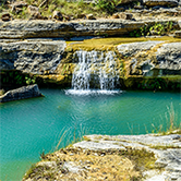
Canyon Lake Gorge
Visit the Canyon Lake Gorge
|
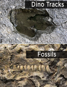
During one week in the summer of 2002, more than 34 inches of rain fell in the upper watershed of the Guadalupe River, setting off a torrent of floodwater that carved a perfectly fascinating geological wonder - the Canyon Lake Gorge - out of the earth.
The flood roared through the Hill Country northwest of New Braunfels, tearing away soil, ripping up huge trees, crumpling houses and sending a rush of water from swollen Canyon Lake over its spillway for the first time since the reservoir was completed in 1964. The historic flood sliced open the ground below the spillway, creating a gigantic 64-acre Gorge and exposing ancient, cretaceous limestone, fossils and even dinosaur footprints 110 million years old. It is a textbook example highlighting Hill Country geology and the exposed Trinity Aquifer, clearly showing faults, fractures and seeps in the limestone. Limestone layers created from an ancient sea are visible, and visitors admire waterfalls and springs where the aquifer is exposed. |
|
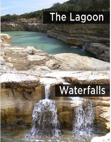
The Gorge is a real-life classroom in which visitors learn how the aquifer's underground permeable rock cavities soak up, store, and move rainwater that many in Central Texas depend on for drinking water and irrigation.
The Gorge Overlook Trail (GOT) runs along the northern rim of the gorge and is approximately two miles long round trip. Safety railings and informational signage at each of the eight observation nodes is currently being installed. Once fully developed, the GOT will allow people of all ages and abilities to view the gorge from above and at their own pace. This hike will not have an age restriction for younger children and will not require a reservation as with
guided tours.
Plans are also being developed to make the trail ADA accessible to the first two observation nodes. The ADA trail improvement is made possible through a grant from the Texas Parks and Wildlife Department.
This new trail experience and facility will hopefully be open to the public in early 2021.
Geologic Framework and Hydrogeologic Characteristics of the Edwards Aquifer Outcrop, Comal County, Texas
Water-Resources Investigations Report 94-4117
Prepared in cooperation with the Edwards Underground Water District
By T.A. Small and J.A. Hanson
Prepared in cooperation with the Edwards Underground Water District
By T.A. Small and J.A. Hanson
|
ABSTRACT
All of the hydrogeologic subdivisions within the Edwards aquifer outcrop in Comal County have some porosity and permeability. The most porous and permeable appear to be hydrogeologic subdivision VI, the Kirschberg evaporite member of the Kainer Formation; hydrogeologic subdivision III, the leached and collapsed members, undivided; and hydrogeologic subdivision II, the cyclic and marine members, undivided, of the Person Formation. The two types of porosity in the Edwards aquifer outcrop are fabric selective, which is related to depositional or diagenetic elements and typically exists in specific stratigraphic horizons; and not fabric selective, which can exist in any litho stratigraphic horizon. Permeability, the capacity of porous rock to transmit water, depends on the physical properties of the rock such as pore size, shape, distribution, fissuring, and dissolution. |
Two faults, Comal Springs and Hueco Springs, completely, or almost completely, offset the Edwards aquifer along much of their respective traces across Comal County. Porous and permeable Edwards aquifer limestone is juxtaposed against impermeable upper confining units in these areas. These faults completely, or almost completely, offset the Edwards aquifer and are thought to be barriers or partial barriers to groundwater flow where the beds are juxtaposed. In Comal County, the Edwards aquifer is probably most vulnerable to surface contamination in the rapidly urbanizing areas on the Edwards aquifer outcrop. Possible contamination can result from spills, leakage of hazardous materials, or runoff onto the intensely faulted and fractured, karstic limestone outcrops characteristic of the recharge zone. |
From Our GEAA Partner
|
The Edwards Aquifer provides drinking water for over 1.7 million people in Central Texas. San Antonio pumps aquifer water from the Southern segment of the Edwards Aquifer. Over 50,000 people in the Austin area rely on the Barton Springs segment of the Edwards Aquifer. Barton Springs and Barton Creek also contribute water to the City of Austin’s
municipal supply. Growing population along the Edwards Aquifer watershed is putting pressure on ground water supplies. Over-pumping of the Edwards and Trinity aquifers threatens to reduce and potentially dry up springs and rivers, jeopardizing the existence of rare species and the health of local and coastal economies – and of our drinking water. AQUIFER AT RISK The Edwards Aquifer is the lifeblood for dozens of communities – and millions of people – in Central and South Central Texas. So too for over 60 species of plants and animals that live in the Edwards Aquifer Ecosystem and nowhere else on the planet. Despite the immeasurable value of this natural resource, human activity – urbanization – now threatens to taint the water of the Edwards Aquifer with a slew of pollutants – from fertilizers and pesticides to toxic metals and sewage spills. The Edwards Aquifer and its Great Springs are highly vulnerable because of their unique geology and hydrology. Caves, sinkholes, faults, and fractures dot the landscape of the Recharge Zone, where water plunges underground, where it encounters limestone rock that as been eroded over time to create large underground channels for the water to flow. |
Water in the Edwards Aquifer moves at a rate of thousands of feet per day; compared to velocities of a few feet per year in other aquifers. This rapid movement and the relatively large size of the spring outlets provide none of the filtration, absorption, and slow water flow that protect many aquifers from contamination.
Development in the Recharge Zone and upstream of the Recharge Zone in the Contributing Zone of new subdivisions, shopping centers, office buildings, highways, golf courses, sewer lines, wastewater treatment plants, and rock quarries all create increased risk of contamination of the aquifer. SAVE THE AQUIFER With the Austin/San Antonio corridor expected to grow continually into the future and demand on Edwards Aquifer water also expected to grow, if we are are to protect the quality and quantity of water in the aquifer, we must grow downstream of the sensitive Edwards Aquifer. We support sustainable development that does not strain local water resources or pollute local water bodies. Some development over the Edwards Aquifer can take place without damaging the aquifer, but not the level of development that business boosters are planning for over the aquifer. New development downstream of the Edwards Aquifer can take advantage of deeper soils, flatter terrain, and fewer endangered species or unique and fragile geologic features, like caves. New development must respect existing communities and neighborhoods. |